Gatineau's growth from a small timber town into a major urban center along the Ottawa River has brought unique geotechnical challenges. The city's expansion into the Gatineau Hills and the floodplain of the Gatineau River means that soil erosion is a constant concern for developers and municipalities alike. In our experience, the interaction between the sensitive Leda clay deposits—common in the Ottawa Valley—and the sandy-silt layers of the upland areas creates a complex erosion risk profile. Before any excavation or slope modification, a thorough soil erosion analysis helps identify vulnerable zones, especially where the water table is shallow or where seasonal snowmelt increases runoff. This evaluation is often paired with an infiltration test to better understand how quickly the subsoil can absorb water, which directly influences erosion potential.
Leda clay in the Ottawa Valley can lose up to 90% of its strength when saturated, making erosion analysis critical before any slope excavation.
Scope of work in Gatineau
Typical technical challenges in Gatineau
The Ottawa Valley experiences freeze-thaw cycles up to 60 times per winter, which directly impacts the soil erosion analysis in Gatineau. When ice lenses form and melt, the soil structure loosens, increasing its susceptibility to sheet and rill erosion during spring runoff. The region's clay-rich subsoils are prone to piping—internal erosion that creates subsurface voids—a phenomenon often underestimated in standard assessments. Without proper analysis, a seemingly stable slope can fail within a single heavy rainfall event, as seen in several residential subdivisions near the Gatineau River in 2019. Incorporating seasonal moisture variation into the erosion model is not optional here; it is essential for reliable long-term predictions.
Our services
We offer specialized soil erosion analysis for Gatineau properties, from small residential lots to large commercial developments.
RUSLE/Factor Analysis & Sediment Modeling
Quantitative erosion risk assessment using the Revised Universal Soil Loss Equation adapted for Canadian conditions. Includes GIS-based mapping of erosion-prone areas and sediment delivery ratios tailored to Gatineau's sub-basins.
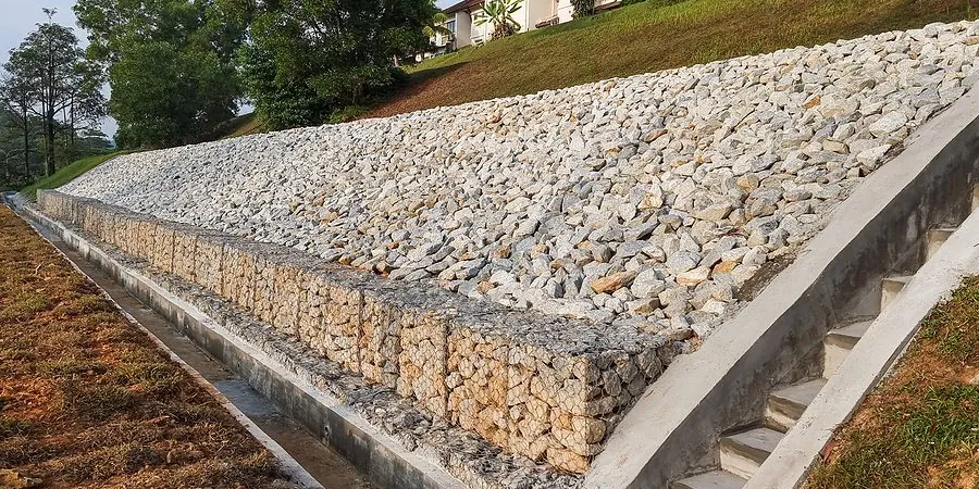
Slope Stability & Erosion Control Design
Combined geotechnical and hydraulic analysis for slopes, embankments, and riverbanks. Recommendations include vegetative stabilization, riprap sizing, and drainage improvements per CSA standards.
Frequently asked questions
What is the difference between soil erosion analysis and a standard geotechnical investigation?
Standard geotechnical investigations focus on bearing capacity and settlement, while soil erosion analysis specifically evaluates the resistance of soil to detachment by water or wind. It measures parameters like erodibility, shear stress, and sediment transport, which are not part of a routine soil report.
How much does a soil erosion analysis cost in Gatineau?
The cost typically ranges from CA$1,080 to CA$3,800 depending on site size, number of samples, and complexity of the terrain. A small residential lot with one slope may fall at the lower end, while a multi-hectare development with several drainage channels will be at the higher end.
Do I need an erosion analysis for a small construction site in Gatineau?
If your site involves any slope steeper than 3:1, is within 30 meters of a watercourse, or has exposed clay soil, an erosion analysis is strongly recommended. Municipal bylaws in Gatineau require sediment and erosion control plans for sites over 0.1 hectares.
What ASTM standards apply to soil erosion analysis?
Key standards include CSA + CSA + CSA + CSA + ASTM D422 (also CFEM Ch 2) (also CFEM Ch 2) (also CFEM Ch 2) (also CFEM Ch 2) (also CFEM Ch 2) for particle size distribution, CSA A23.2-2A for Atterberg limits, and ASTM D4647 for dispersion characteristics. For field erodibility testing, ASTM D5084 is used for hydraulic conductivity of soil.