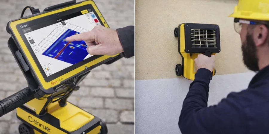
Gatineau's growth since the mid-20th century has pushed development into the old floodplains of the Ottawa River and the glaciolacustrine clays of the Champlain Sea. These soft, sensitive soils — known as Leda clay — make subsurface imaging a critical first step. Our GPR (Ground Penetrating Radar) survey in Gatineau uses 250 MHz to 1.5 GHz antenna arrays to detect buried utilities, voids, and stratigraphic changes. We cross-reference radargrams with existing borehole logs and, when needed, combine with calicatas exploratorias to ground-truth anomalies before excavation. The Laurier-Taché corridor alone has seen three major utility strikes in the past five years that could have been avoided with proper radar mapping.
A 400 MHz antenna can resolve a 50 mm PVC pipe at 2.5 m depth in dry sand — but only 1.2 m in saturated Leda clay.
Scope of work in Gatineau
Demonstration video
Typical technical challenges in Gatineau
Compare the Hull sector — built on compact alluvial sands — with the Lac-Beauchamp area, where thick organic deposits and soft marine clay dominate. In Hull, a GPR survey might show clear rebar in a 20 cm slab. In Lac-Beauchamp, the same survey could fail to detect a gas line at 1.8 m because the clay's electrical conductivity dissipates the radar wave. We've seen contracts where a contractor assumed uniform conditions across Gatineau and hit a high-voltage feeder during piling. Skipping a GPR survey on variable terrain is a false economy — the cost of one utility strike in downtown Gatineau can exceed the entire survey budget tenfold.
Our services
We tailor each GPR survey in Gatineau to the site's specific soil conditions and project objectives. Our three core service packages cover the most common scenarios:
Utility Mapping & Clearance
Pre-excavation scanning of all metallic and non-metallic utilities (PVC, concrete, fiber optic) using multi-frequency GPR. Deliverable: geo-referenced CAD plan showing pipe/duct locations to ±5 cm accuracy.
Void & Cavity Detection
Targeted surveys to locate sinkholes, erosion voids, or abandoned manholes beneath pavements and foundations. Typically combined with a ground-truth borehole if an anomaly exceeds 0.5 m in diameter.
Structural Concrete Scanning
Rebar mapping, post-tension cable location, and concrete thickness assessment in slabs, walls, and bridge decks. Uses 1.5 GHz antenna for rebar spacing down to 5 cm cover depth.
Frequently asked questions
How deep can GPR see in typical Gatineau soils?
In dry sands and gravels (common along the Gatineau River), we reach 4–6 m with a 250 MHz antenna. In the saturated Champlain Sea clays of Plateau or Aylmer, penetration drops to 1.5–2.5 m. We always run a calibration test at each site to confirm actual depth range.
What is the typical cost of a GPR survey in Gatineau?
A standard utility mapping survey for a 2,000 m² residential lot runs between CA$10.890 and CA$1.920 depending on access, clutter, and reporting detail. Larger commercial sites with full CAD deliverables fall at the higher end. We provide firm quotes after a brief site walk.
Can GPR distinguish between a water pipe and a gas pipe?
GPR detects the pipe itself (dielectric contrast), not the contents. A 150 mm PVC water main and a 150 mm PVC gas line look identical on radar unless we use ground-truthing with an ensayo CPT or potholing. We flag all anomalies equally and recommend selective exposure for critical lines.
Do you need to close the street to perform a GPR survey?
Not usually. Our GPR cart is pedestrian-operated and works in live traffic lanes with a single spotter. For large arterial roads (e.g., Boulevard Saint-Joseph), we coordinate with Ville de Gatineau for lane closures during off-peak hours. No excavation or surface damage occurs.